The full name of the ICESat-2 is Ice, Cloud, and Land Elevation Satellite 2, which will be released in the middle of September.
Washington … News Time
Increasing the temperature of the earth, the global warming pole, north and south, is increasingly melting the sea reserves due to rising sea level. On which one side of the various countries consist of several populated areas of the island if the fear of their sinking was born, the ice reserves that were helpful in keeping the temperature of the earth compared to the sun’s flame. If there is no land, the boundary will increase further, now NASA’s new satellite is being sent to the middle of the latest month for collecting and analyzing the latest data on this situation.
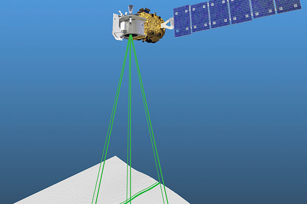
The full name of the ICESat-2 is Ice, Cloud, and land Elevation Satellite 2, which will be released in the middle of September. This satellite will note the snow deficiency in every season and even on the ground, any scarcity or increase in ice reserves will be able to feel even in the fifth part of an inch. The ICESat-2 has the latest laser technology and other devices installed. This planet will take a look at the change in the Earth’s top levels and sheets for 3 years. NASA Sciences about ICESat-2 has said Tom Wagner the satellite itself will take a look at the larger area than the US and there will be ice available there.
Apart from this, the layers of ice on the puban will also be investigated those who are melting rapidly and their intimidation are being exposed to rising global ocean levels. This latest satellite cost $ 1 billion. The laser mounted in it will be made of ice knee and a dimensional picture of growth. Other experts have said ICESat-2 as an excellent innovator it will provide clear picture and data, looking at the snow on the earth and seas, while on a 500 km height. This is the most important system name Advanced Topographic Laser Altimeter System (Atlas) which will remove green laser radicals. In some way, some laser rays that fall in the snow will reach the satellite again and it’s possible to make a detailed map of ice.